Water Quality Monitoring

So, what is the problem?
One easy to see problem is that the water is not very clear. Lots of small particles in the water make the water look dark or muddy. That is due to the fact that, especially after a rainfall, a lot of the material suspended in the water is in fact mud. Some of this sediment suspended in the water gets rinsed from the land into the watershed during rainfall. Some of it can be directly eroded by the faster moving and higher water following the rain.
Is this sediment a problem? Yes, in a few ways. First off, the water looks less appealing. Second, all of this sediment has to go somewhere. The faster moving river water carries the sediment into the lake, however when the water slows down in the deeper lake the sediment begins to settle to the bottom. Heavy sediment loads can create thick layers of mud on the bottom and fill in the basins of the lake. High sediment water is more difficult to filter for water intakes causing additional problems for municipal water supplies. Last but definitely not least, where there is sediment there are other things in the water that came along with it. Various forms of pollution come along for the ride, much of which cannot be seen.
One form of pollution that enters the water through similar means as the sediment is what scientists ever-so-politely call nutrients. You know, stuff that makes other things grow. In the plant world it is called fertilizer. You may have heard that the grass always grows greener over the septic tank. You get the idea – nutrients. These nutrients can come from peoples’ yards, farmers’ fields, animal operations, etc.
These nutrients stimulate the growth of algae and other microscopic organisms called phytoplankton. When phytoplankton (this includes algae) have all of the ingredients they need to grow – enough nutrients and light and other things that there is usually plenty of, their population increases exponentially until one of the ingredients runs low. This adds more small particles to the water and usually turns it some shade of green.
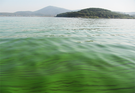
So what’s wrong with phytoplankton? Nothing in small amounts. In large amounts there are all of the problems associated with high sediment… and more. Some phytoplankton are toxic to humans and/or fish and can cause a variety of health problems. In 2014 a toxic algal bloom in Lake Erie became so bad that Toledo residents were told not to drink their water. Second, since phytoplankton are living things with a short lifespan, they die and fall toward the bottom. As they decay, they react with and use up oxygen that was dissolved in the water. Sometimes they use up all of it – especially toward the bottom. If there is no oxygen in the water, fish and other living things can’t live there. If they can’t find water with enough oxygen in it, they die.
Oxygen (and other gasses) naturally pass from the air to the water or vice-versa to try to reach a balance. Without some outside force stirring up the water it would take much longer for the oxygen to reach the bottom than it takes to get used up by decaying organic material. That is why quite often the water at the bottom has low or no oxygen.
What can mix the water? It takes some outside force to mix up the water – forces that make the water move make the water mix. The wind is one. When the wind blows over the water it makes waves, it can start the water moving in the direction of the wind, and it makes turbulence. Turbulence mixes water. What resists mixing? If the water at the bottom is heavier (more dense), it is harder to lift it up and mix it. If the turbulence is not energetic enough, it can’t lift much dense water from the bottom and it doesn’t mix.
Temperature is the biggest factor in a lake that determines the density. Colder water is more dense (with a small exception right near freezing). When the sun and warm air heats the water at the surface it becomes less dense than the water at the bottom. Turbulence usually only mixes the water part way down. We can get a warm layer on top and a cold layer on the bottom. This stratification of the water often divides the water into layers where the surface has enough oxygen and the bottom has low oxygen. When the weather is turning colder, the water near the surface can cool to a lower temperature than the bottom, become more dense and fall to the bottom. This also mixes the water.
What do we measure?
Turbidity is related to the amount of sediment in the water. The sensor we use shines a light into the water and measures how much light is reflected off of particles in the water back to the sensor. There are many reasons why this does not directly tell us the mass of particles in the water, but in natural settings they are closely related.
To measure phytoplankton, we take advantage of the fact that chlorophyll will fluoresce in light. A particular color of light is transmitted into the water and the received light is filtered to measure how much of the received light is fluorescence. This is closely related to the amount of phytoplankton in the water.
We can directly measure the amount of oxygen in the water and the temperature of the water. We also measure the pH of the water and its conductivity. Most living organisms in water have a fairly narrow range of pH in which they thrive. Conductivity helps to identify where the water has come from. Water from the surface or the bottom may have a different conductivity than water coming in from the river and streams, for example. Therefore, a rapid change in conductivity over time tells us that the water has moved to our sensors from somewhere else.
Vertical Profiling
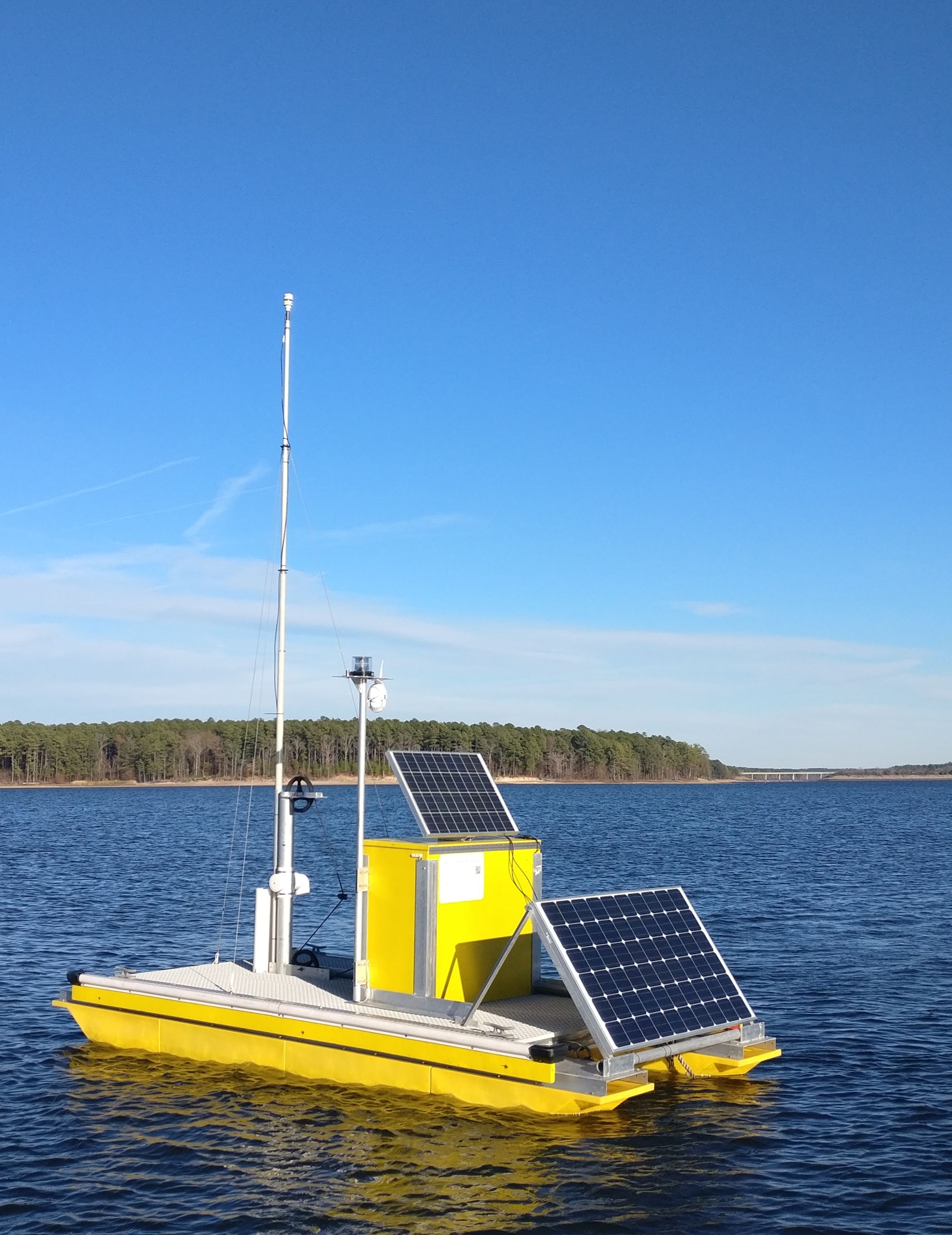
All of these parameters are measured in contact with, or very near the sensors that we use. Since the water may form layers and may also have movement from one layer to the next it is essential to measure these parameters all the way from the surface to the bottom. This is often done by lowering an instrument from the side of a boat, which is extremely labor intensive. The vertical profiling platform lowers a water quality instrument every 30 minutes automatically throughout the water column. Data are collected on-board the platform’s computer and sent to databases at the Institute of Marine Sciences to be processed. Within a few minutes a new image representing the data is generated and published on the web.
See the data on the Vertical Profiling Data Page